 |
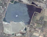
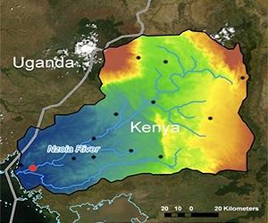
Washington DC (SPX) Nov 12, 2010 In September 2010, SERVIR Science Coordinator Dr. Ashutosh Limaye made his first journey to the SERVIR-Africa node at the Regional Center for Mapping of Resources for Development, or RCMRD, in Nairobi, Kenya. In this part of the world, flood estimation is a hot topic. Limaye's discussions with the RCMRD team and stakeholders from the Kenya Meteorological Department and USAID's Famine Early Warning Systems Network highlighted the importance of flood-potential mapping, flood forecasting and post-event flood mapping for the region. A hydrologist by training, Limaye is attuned to the economic and public health ramifications of better hydrologic estimation in East Africa. "Rift Valley Fever is critical in that part of the world, where livestock transport and the livelihood of a vast population come to a grinding halt because of travel restrictions induced by the disease," he said. Without a doubt, he said, improved stream flow and flood estimation can have multiple important applications in the SERVIR-Africa region, including flood and drought disaster forecasting and response; agricultural and food security impacts; and Rift Valley Fever risk mapping, to name just a few. In response to these needs, SERVIR-Africa and the Kenya Meteorological Department are teaming to give decision-makers flood forecasts with longer lead-times. SERVIR-Africa has investigated various regional and global hydrologic models for flood modeling, which shows scientists where standing water will occur above a defined threshold. A team at NASA's Goddard Space Flight Center in Greenbelt, Md., and the University of Oklahoma in Norman pioneered the hydrologic modeling efforts in East Africa for SERVIR-Africa. They developed the hydrologic model based on the state-of-the-art Variable Infiltration Capacity model. Limaye is enhancing those efforts by incorporating forecast components into the modeling system. For example, in the Nzoia watershed in Lake Victoria Basin, SERVIR-Africa is working with researchers at Goddard, Oklahoma University and NASA's Marshall Space Flight Center in Huntsville, Ala., to implement and evaluate a higher resolution (approximately 1 km) distributed hydrologic model: the Coupled Routing and Excess Storage, or CREST, water balance model. In Lake Victoria Basin, the CREST model uses real-time rainfall data from the Tropical Rainfall Measuring Mission satellite as a boundary condition to map streamflow, evapotranspiration and soil moisture. For flood forecasting, SERVIR-Africa is working with the Kenya Meteorological Department to incorporate their atmospheric model-based rain forecasts into the CREST model in place of observed Tropical Rainfall Measuring Mission data. These rain forecasts will give decision-makers a longer lead time for flood forecasting, allowing more time for preparation and reaction. These forecasts will be available through the SERVIR-Africa website. The SERVIR program is operated by the Earth Science Division's Applied Sciences Program in NASA's Science Mission Directorate in Washington. Three other NASA field centers work with Marshall and Goddard on the program: NASA's Ames Research Center in Moffet Field, Calif., NASA's Jet Propulsion Laboratory in Pasadena, Calif., and NASA's Langley Research Center in Hampton, Va.
Share This Article With Planet Earth
Related Links SERVIR at NASA Earth Observation News - Suppiliers, Technology and Application
 Enhancing Sustainable Development Of Earth
Denver CO (SPX) Nov 12, 2010 From monitoring vanishing glaciers to the accounting of forestry, hydropower and mining assets as steps to boost sustainable development here on Earth, the power of satellite remote sensing plays an increasingly vital role. These topics and others are highlighted in the Fall 2010 issue of the quarterly print and online publication - Imaging Notes magazine. "Secure World Foundation in ... read more |
|
| The content herein, unless otherwise known to be public domain, are Copyright 1995-2010 - SpaceDaily. AFP and UPI Wire Stories are copyright Agence France-Presse and United Press International. ESA Portal Reports are copyright European Space Agency. All NASA sourced material is public domain. Additional copyrights may apply in whole or part to other bona fide parties. Advertising does not imply endorsement,agreement or approval of any opinions, statements or information provided by SpaceDaily on any Web page published or hosted by SpaceDaily. Privacy Statement |

 del.icio.us
 Digg
Digg Reddit
 YahooMyWeb
 Google