 |
Washington DC (SPX) Aug 06, 2010 Intense fires continued to rage in western Russia on August 4, 2010. Burning in dry peat bogs and forests, the fires produced a dense plume of smoke that reached across hundreds of kilometers. The Moderate Resolution Imaging Spectroradiometer (MODIS) captured this view of the fires and smoke in three consecutive overpasses on NASA's Terra satellite. The smooth gray-brown smoke hangs over the Russian landscape, completely obscuring the ground in places. The top image provides a close view of the fires immediately southeast of Moscow, while the lower image shows the full extent of the smoke plume. The fires along the southern edge of the smoke plume near the city of Razan, top image, are among the most intense. Outlined in red, a line of intense fires is generating a wall of smoke. The easternmost fire in the image is extreme enough that it produced a pyrocumulus cloud, a dense towering cloud formed when intense heat from a fire pushes air high into the atmosphere. The lower image shows the full extent of the smoke plume, spanning about 3,000 kilometers (1,860 miles) from east to west. If the smoke were in the United States, it would extend approximately from San Francisco to Chicago. The MODIS sensor acquired the right section of the image starting at 5:55 UTC (10:55 a.m. local time, 8:55 a.m. in Moscow). The center section is from the overpass starting at 7:35 UTC (11:35 local time, 10:35 in Moscow), and the westernmost section was taken at 9:10 UTC (12:10 p.m. local time in Moscow). Early analyses of data from the Multi-angle Imaging Spectroradiometer (MISR), another instrument on the Terra satellite, indicates that smoke from previous days has at times reached 12 kilometers (six miles) above Earth's surface into the stratosphere. At such heights, smoke is able to travel long distances to affect air quality far away. This may be one reason that the smoke covers such a large area. The pyrocumulus cloud and the detection of smoke in the stratosphere are good indicators that the fires are large and extremely intense. According to news reports, 520 fires were burning in western Russia on August 4. MODIS detected far fewer. It is likely that the remaining fires were hidden from the satellite's view by the thick smoke and scattered clouds. High temperatures and severe drought dried vegetation throughout central Russia, creating hazardous fire conditions in July. As of August 4, 48 people had died in the fires and more than 2,000 had lost their homes throughout central Russia, said news reports. The dense smoke also created hazardous air quality over a broad region. Visibility in Moscow dropped to 20 meters (0.01 miles) on August 4, and health officials warned that everyone, including healthy people, needed to take preventative measures such as staying indoors or wearing a mask outdoors, reported the Wall Street Journal. In the image, Moscow is hidden under a pall of smoke. Close to the fires, smoke poses a health risk because it contains small particles (soot) and hazardous gases that can irritate the eyes and respiratory system. Smoke also contains chemicals that lead to ozone production farther away from the fires.
Share This Article With Planet Earth
Related Links Earth Observatory Earth Observation News - Suppiliers, Technology and Application
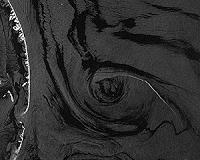 TerraSAR-X Image Of The Month: Tracking The Catastrophic Oil Spill
Bonn, Germany (SPX) Aug 04, 2010 Bonn, Germany (SPX) Aug 04, 2010 If an oil spill wasn't responsible for the formations in these TerraSAR-X images, they might seem like the work of an artist. The images were acquired over the Gulf of Mexico on 9 July 2010. For researchers, such imagery is key in forecasting the distribution of the oil slick. TerraSAR-X mapped the oil-polluted area in the Gulf of Mexico in a series of ima ... read more |
|
| The content herein, unless otherwise known to be public domain, are Copyright 1995-2010 - SpaceDaily. AFP and UPI Wire Stories are copyright Agence France-Presse and United Press International. ESA Portal Reports are copyright European Space Agency. All NASA sourced material is public domain. Additional copyrights may apply in whole or part to other bona fide parties. Advertising does not imply endorsement,agreement or approval of any opinions, statements or information provided by SpaceDaily on any Web page published or hosted by SpaceDaily. Privacy Statement |


 del.icio.us
 Digg
Digg Reddit
 YahooMyWeb
 Google