 |
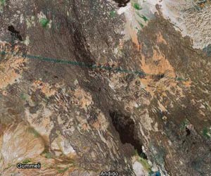
Leicester, UK (SPX) Apr 07, 2011 Astrium GEO-Information Services has completed a geological interpretation study of the East Africa Rift System (EARS) and the surrounding area that is increasingly becoming an exploration hotspot for the Oil, Gas and Minerals industry. For the first time, these organisations can have access to an 'off-the-shelf' set of integrated data to highlight the hydrocarbon prospectivity and oil seeps in the region. Andrew Stroomer, UK Managing Director of Astrium GEO-Information Services said: "The East African Rift System is increasingly viewed as a hydrocarbon exploration hotspot, particularly given recent discoveries in the Albertine Rift and offshore Tanzania. Covering approximately 4.5 million square km, our study provides exploration companies with a consistent interpretation of the surface geology and the location of hydrocarbon seeps in the region. "Previously organisations would have had to amalgamate existing datasets - sometimes paper-based - that weren't always consistent, so the availability of this 'off-the-shelf' East Africa data in a digital format should speed up the exploration process and enable increased accuracy," adds Andrew Stroomer. The study covers Eritrea, Djibouti, Somaliland, Ethiopia, Uganda, Kenya, Malawi, Rwanda, Burundi, Tanzania and Mozambique, and is based on Earth Observation data that has been fully integrated with the East Africa and African lakes seeps studies. The interpretation work is based on 15m Landsat 7 ETM+ imagery combined with a 90m SRTM elevation model providing customers with geomorphology and lithological information at the same time. It fully integrates all datasets needed to assess and highlight the hydrocarbon prospectivity, including structural and stratigraphic interpretations, capture of major drainage channels and water bodies, and oil seep locations as points and vectors of slick outlines. It also includes radar imagery for key areas, extracts from the oil seeps database covering major rift lakes, as well as hardcopy map sheets at 1:500 000 scale. By combining the interpretation with the identified hydrocarbon seeps their geological context can be readily assessed. Surface evidence for several phases of rifting can be identified from the remote sensing data, with significant overprinting between events. The study also demonstrates that oil seeps predominately occur in the extensive lakes within the Western Branch of the Rift including Lake Albert, Edward and Tanganyika. With 25 years' experience working closely with exploration companies, Astrium GEO-Information Services is committed to developing valuable geo-information to support exploration companies worldwide. A similar study was recently completed for Iraq and the Zagros Fold Belt / Iran. The next area of focus will be the Eastern Mediterranean, where Astrium plans to interpret both on and offshore data. Astrium GEO-Information Services will be attending its first major Oil and Gas sector event under its new entity at the upcoming AAPG Annual Convention - AAPG 2011 - 10-13 April in Houston, Texas USA. Astrium GEO-Information Services was previously known as Infoterra Ltd before it 'teamed-up' with SPOT Image in December 2010. By combining the interpretation study with identified hydrocarbon seeps, the geological context of seeps can be readily assessed
Share This Article With Planet Earth
Related Links Astrium GEO-Information Services Earth Observation News - Suppiliers, Technology and Application
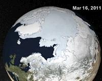 Arctic Ice Gets A Check Up
Grreenbelt MD (SPX) Apr 01, 2011 Scientists tracking the annual maximum extent of Arctic sea ice said that 2011 was among the lowest ice extents measured since satellites began collecting the data in 1979. Using satellites to track Arctic ice and comparing it with data from previous years is one way that scientists track change in the Arctic system. "For the first 20 years of the satellite record, the average annual maxim ... read more |
|
| The content herein, unless otherwise known to be public domain, are Copyright 1995-2010 - SpaceDaily. AFP and UPI Wire Stories are copyright Agence France-Presse and United Press International. ESA Portal Reports are copyright European Space Agency. All NASA sourced material is public domain. Additional copyrights may apply in whole or part to other bona fide parties. Advertising does not imply endorsement,agreement or approval of any opinions, statements or information provided by SpaceDaily on any Web page published or hosted by SpaceDaily. Privacy Statement |

 del.icio.us
 Digg
Digg Reddit
 YahooMyWeb
 Google