 |
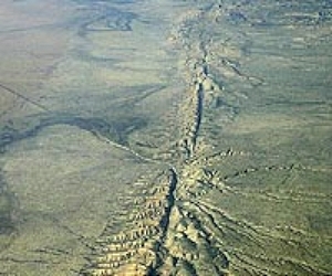
Los Angeles CA (SPX) Oct 04, 2010 For the first time, scientists are using advanced technology and an innovative vessel to study, image, and map the unexplored offshore Northern San Andreas Fault from north of San Francisco to its termination at the junction of three tectonic plates off Mendocino, Calif. The team includes scientists from NOAA's National Marine Fisheries Service, Oregon State University, the California Seafloor Mapping Program, the U.S. Geological Survey and Woods Hole Oceanographic Institution. The expedition which concludes Sunday is sponsored by NOAA's Office of Ocean Exploration and Research. While the fault on land is obscured by erosion, vegetation and urbanization in many places, scientists expect the subsea portion of the fault to include deep rifts and high walls, along with areas supporting animal life. The expedition team is using high-resolution sonar mapping, subsurface seismic data and imaging with digital cameras for the first-ever three-dimensional bathymetric-structural map that will model the undersea Northern San Andreas Fault and its structure. Little is known about the offshore fault due to perennial bad weather that has limited scientific investigations. "By relating this 3-D model with ongoing studies of the ancient record of seismic activity in this volatile area, scientists may better understand past earthquakes - in part because fault exposure on land is poor, and the sedimentary record of the northern California offshore fault indicates a rich history of past earthquakes," said Chris Goldfinger, co-principal investigator and marine geologist and geophysicist at Oregon State University in Corvallis, Ore. "The model will also benefit geodetic studies of the buildup of energy to help better understand the potential for earthquakes." More than a century after the 1906 Great San Francisco Earthquake, the science team is also exploring the fault for lessons associated with the intertwined relationships between major earthquakes and biological diversity. Evidence shows that active fluid and gas venting along fast-moving tectonic systems, such as the San Andreas Fault, create and recreate productive, unique and unexplored ecosystems. "This is a tectonically and chemically active area," said Waldo Wakefield, co-principal investigator and a research fisheries biologist at NOAA's Northwest Fisheries Science Center in Newport, Ore. "I am looking for abrupt topographic features as well as vents or seeps that support chemosynthetic life - life that extracts its energy needs from dissolved gasses in the water. I'm also looking at sonar maps of the water column and images of the seafloor for communities of life." A variety of sensors and systems are being used to help locate marine life including a NOAA autonomous underwater vehicle (AUV) named 'Lucille.' Elizabeth Clarke, a NOAA fisheries scientist, is coordinating Lucille's operations and obtaining photographic information about fauna associated with the fault. The AUV and its sensors can dive to nearly one mile (1,500 meters), but depths associated with this expedition will range between approximately 230 to 1100 feet (70 to 350 meters). Early in the expedition, scientists collected bathymetric and subsurface seismic reflection data to guide them to specific areas of interest for follow-on and more detailed operations. The AUV's high-definition cameras are obtaining multiple images to be stitched into "photo mosaics" showing detailed fault structure and animal life. The first part of the expedition is operating from Research Vessel Derek M. Baylis, a "green" research vessel primarily powered by sail and owned by Sealife Conservation, a nonprofit organization. The expedition will track the carbon footprint of the 65-foot energy efficient Baylis and compare results to conventional vessels. AUV operations are being conducted aboard the Research Vessel Pacific Storm, operated by Oregon State University's Marine Mammal Institute. The ship and AUV team joined the expedition offshore of Fort Bragg on Sept. 25. As the expedition progresses, NOAA's Ocean Explorer website features maps and images of the fault and associated ecosystems, logs from scientists at sea, and lesson plans that align with National Science Education Standards at three grade levels.
Share This Article With Planet Earth
Related Links NOAA Office of Ocean Exploration and Research Sealife Conservation Tectonic Science and News
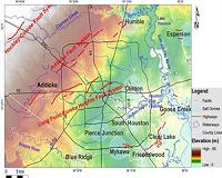 Geologists Find Parts Of Northwest Houston Sinking Rapidly
Houston TX (SPX) Sep 30, 2010 A large section of northwestern Harris County - particularly the Jersey Village area - is sinking rapidly, according to a University of Houston (UH) geologist who has analyzed GPS data measuring ground elevation in the Houston area. Some points in Jersey Village are subsiding by up to 5.5 centimeters (about 2 inches) a year, said Shuhab Khan, an associate professor of geology at UH. Khan, ... read more |
|
| The content herein, unless otherwise known to be public domain, are Copyright 1995-2010 - SpaceDaily. AFP and UPI Wire Stories are copyright Agence France-Presse and United Press International. ESA Portal Reports are copyright European Space Agency. All NASA sourced material is public domain. Additional copyrights may apply in whole or part to other bona fide parties. Advertising does not imply endorsement,agreement or approval of any opinions, statements or information provided by SpaceDaily on any Web page published or hosted by SpaceDaily. Privacy Statement |

 del.icio.us
 Digg
Digg Reddit
 YahooMyWeb
 Google