 |
Greenbelt MD (SPX) Feb 09, 2011 If you're distributing 412 million data products in a year to more than 1.1 million users, how do you ever make sure people are getting what they want? The Earth Observing System Data and Information System (EOSDIS) Project based at Goddard Space Flight Center, Greenbelt, Md., came up with a simple formula: They ask. EOSDIS is the network of Earth science data centers that process, store, and make available the trove of data from NASA's past and current Earth-observing satellites. For the past seven years, EOSDIS management has collected thousands of responses from users of its system as a way to both gather metrics and improve on its delivery. EOSDIS works with the American Customer Satisfaction Index (ACSI) to systematically track its standing and progress through the eyes of its users. In the recently released ACSI ratings for 2010, EOSDIS achieved a customer satisfaction score well above the standard for government agencies and even higher scores in several key categories. EOSDIS scored a 77 on a scale of 0 to 100, while the government benchmark is 65. EOSDIS has maintained scores in the high 70s over the past several years. "This accomplishment is particularly noteworthy given its consistency, even though customer expectations rose during that period," said Ron Oberbillig, Chief Operating Officer of the Federal Consulting Group, executive agent within the federal government that works with ACSI on behalf of all agencies. Oberbillig particularly lauded EOSDIS for scores in the upper eighties when customers were asked about their likelihood to use the data centers in the future and willingness to recommend the data centers to colleagues. "We use the ACSI surveys as a way to measure our performance, but also as a way to keep improving on what we do" said Jeanne Behnke, EOSDIS Deputy Project Manager for Operations at NASA Goddard.
Behind the Scenes EOSDIS manages constant streams of data for scientists to dissect and discover new knowledge about how our planet's dynamic systems work and interact with one another. But before any scientific investigation can begin, the raw data itself must be received, stored, processed and made available. It's a process that often occurs behind the scenes but ultimately enables all the NASA-related studies of Earth and its climate. EOSDIS manages this flow of information - from satellites in space to data processing facilities to a scientist's desktop - with a network of 12 Earth science data centers in the U.S. These Earth science data centers are located at NASA centers or partner institutions and specialize in specific types of datasets, such as snow and ice, atmospheric or ocean data. NASA's Earth Observing System (EOS) was devised to make long-term, comprehensive measurements of Earth's interrelated systems - to capture their fundamental nature and any natural or man-made changes. In the 1990s, EOS identified 24 key measurements of Earth systems, and EOSDIS manages the gathering and distribution of those measurements from end to end - from command and control of several satellites, to coordination of data gathering through ground stations the world over, to the distribution interface on NASA websites where scientists can download data. The wide-ranging effort essentially takes a long-term measure of the scope of Earth's land, atmosphere and ocean systems. While EOS is only about 15 years old, these data records will become more valuable as they capture a longer period of time and more natural and man-made variability in the various Earth systems. That makes the EOSDIS task of not only processing but also archiving all NASA data a vital component to the future of Earth science.
Moving Forward "At our core, we are delivering an extensive array of products to a national and international base of scientists, researchers, educators, and the general public," Boquist said. "With new data products always coming online and our users' needs constantly changing, the only way to make sure we're succeeding is to ask."
Share This Article With Planet Earth
Related Links EOSDIS Earth Observation News - Suppiliers, Technology and Application
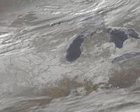 A Snowy US Panorama By Satellite
Greenbelt MD (SPX) Feb 09, 2011 Last week 30 U.S. states were affected by a massive winter storm. This week satellite images created by NASA provide a snowy panorama of that fallen snow. The Geostationary Operational Environmental Satellites (GOES) that cover the U.S. weather, GOES-11 and GOES-13 are operated by NOAA, and the NASA GOES Project at NASA's Goddard Space Flight Center in Greenbelt, Md. creates images and ani ... read more |
|
| The content herein, unless otherwise known to be public domain, are Copyright 1995-2010 - SpaceDaily. AFP and UPI Wire Stories are copyright Agence France-Presse and United Press International. ESA Portal Reports are copyright European Space Agency. All NASA sourced material is public domain. Additional copyrights may apply in whole or part to other bona fide parties. Advertising does not imply endorsement,agreement or approval of any opinions, statements or information provided by SpaceDaily on any Web page published or hosted by SpaceDaily. Privacy Statement |

 del.icio.us
 Digg
Digg Reddit
 YahooMyWeb
 Google