 |
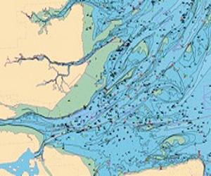
Leicester, UK (SPX) Mar 11, 2011 Astrium GEO-Information Services has introduced new marine and coastal geospatial data that is now downloadable from its www.geostore.com store. The new data includes the Admiralty Raster Charts, and a new generation of vector data known as Marine Themes that is based on information sourced from the UK Hydrographic Office. Easily accessed online, the new marine and coastal data will be particularly relevant for environmental protection and planning professions in the public sector, as well as for commercial organisations - such as utility companies and other organisations - that are planning offshore wind farms or other coastal projects. "The availability of new marine and coastal data strengthens our core Geostore offering, and confirms Geostore's position as the ideal choice for organisations requiring online delivery of critical geospatial information," said Andrew Stroomer, UK Managing Director, Astrium GEO-Information Services. "These new marine and coastal data sets complement our existing expertise in key offshore applications such as the protection of submarine assets and the provision of offshore oil seepage information." In addition to marine and coastal geospatial data, GeoStore provides customers with access to digital terrestrial mapping, aerial imagery and lidar height data. As with all Geostore data products, the new marine and coastal datasets can be fully defined by the customer, providing organisations with the ability to select data on demand - either as an immediate download or even delivered on CD or DVD depending on the amount of data purchased for each application. The Geostore Marine Themes data comprises authoritative data from the UK and other Hydrographic Offices. It consists of a comprehensive suite of individual marine layers corresponding to important marine features: elevation, shipwrecks and obstructions, transport, industrial facilities, administrative and management units and geographical regions. This data is ideal for general situation awareness, planning, site selection and investigation, and outline engineering design. It is also applicable for projects where features need to be selectively displayed or interrogated to create derived outputs. Alternatively, it can be used as a reference base for the user's own data layers. Standard symbology details are provided free of charge allowing for immediate use of the data in GIS. The new Raster Chart data provide a comprehensive marine map base and is ideal for applications where a set of familiar features and symbology is required for reference or as a backdrop to other datasets. Supplied as separate image files, users can easily load the charts they need and use them directly in their Geographical Information Systems (GIS).
Share This Article With Planet Earth
Related Links Astrium GEO-Information Services GPS Applications, Technology and Suppliers
 Coalition To Save Our GPS Launched
Washington DC (SPX) Mar 11, 2011 Representatives from a wide variety of industries and companies have announced that they have joined together to form the "Coalition to Save Our GPS" to resolve a serious threat to the Global Positioning System (GPS) - a national utility upon which millions of Americans rely every day. The threat stems from a recent highly unusual decision by the Federal Communications Commission (FCC) to ... read more |
|
| The content herein, unless otherwise known to be public domain, are Copyright 1995-2010 - SpaceDaily. AFP and UPI Wire Stories are copyright Agence France-Presse and United Press International. ESA Portal Reports are copyright European Space Agency. All NASA sourced material is public domain. Additional copyrights may apply in whole or part to other bona fide parties. Advertising does not imply endorsement,agreement or approval of any opinions, statements or information provided by SpaceDaily on any Web page published or hosted by SpaceDaily. Privacy Statement |

 del.icio.us
 Digg
Digg Reddit
 YahooMyWeb
 Google