 |
Rochester NY (SPX) Mar 31, 2011 Japan needs maps. Not just any kind-detailed informational maps georegistered with latitude and longitude and annotated with simple, self-evident details: this bridge is out, this port is damaged, this farm field is scoured; this one is verdant. Researchers at Rochester Institute of Technology are processing satellite imagery of regions in Japan affected by the 9.0 magnitude earthquake and tsunami that devastated sections of the country's east coast on March 11. The U.S. Geological Survey, a member of the International Charter "Space and Major Disasters," organized the volunteer effort involving about 10 organizations, including Harvard University, George Mason University, Penn State and the Jet Propulsion Laboratory. RIT signed on to process images of the Fukushima Nuclear Power Plant and the cities of Hachinohe and Kesennuma. At the request of the Japanese, scientists at RIT created before-and-after images that can be printed on large sheets of paper. The team uploads 30 megabyte PDFs to the U.S. Geological Survey's website for charter members and Japanese emergency responders to access. "Once we upload it, it's out of our hands," says David Messinger, associate research professor and director of the Digital Imaging Remote Sensing Laboratory in RIT's Chester F. Carlson Center for Imaging Science. "If you have the electronic version, you can make measurements on it," he says. "The assumption is they want the big format so they can print it out, roll it up and take it into the field." The Japanese relief workers requested high-resolution images of the Fukushima Nuclear Power Plant. The RIT team processed imagery looking down into the reactors and the containment shells on March 12, the day after the earthquake and tsunami hit and prior to the explosions at the plant. High-resolution image-maps from March 18 show extensive damage and a smoldering reactor. "We were tasked with the nuke plant Friday [March 18] morning and we uploaded it about 6 that night," says Don McKeown, distinguished researcher in the Carlson Center for Imaging Science. The 13-hour time difference has made the workflow difficult, Messinger notes. "While we're doing this here, it's the middle of the night there, so the feedback loops are slow. "We were pushing hard," he adds. "We wanted to get maps to them before their morning work shift started." They are mapping the area around the power plant as well, processing imagery from a broader view of the terrain used as farmland. "We have a large image of Fukushima," McKeown adds. "We're committed to making a big map of this area. This is a very agricultural region and there are restrictions about food coming out of the area." The RIT team, led by McKeown and Messinger, includes graduate students Sanjit Maitra and Weihua "Wayne" Sun in the Center for Imaging Science and staff members Steve Cavilia, Chris DiAngelis, Jason Faulring and Nina Raqueno. They created the maps using imagery from WorldView 1 and WorldView 2 satellites operated by Digital Globe, a member of RIT's Information Products Laboratory for Emergency Response (IPLER), and GeoEye 1, a high-resolution commercial satellite operated by GeoEye Inc. "This really fits what IPLER is all about-information products," McKeown says. RIT and the University at Buffalo formed IPLER six months before the earthquake struck Haiti in January 2010. Connections with industry partners led RIT to capture and process multispectral and LIDAR images of Port-au-Prince and surrounding towns for the World Bank. "With Haiti, we learned how, in a disaster, to send an imaging instrument into the field, collect the relevant data, get it back to campus and do the right processing to the imagery," Messinger says. "In this case, we're learning how to take imagery that we didn't collect and produce the actual product that will be delivered to the first responders in the field in a very short time frame. We've learned a lot about the second phase of the process now."
Share This Article With Planet Earth
Related Links Rochester Institute of Technology Earth Observation News - Suppiliers, Technology and Application
 Earth Movements From Japan Earthquake Seen From Space
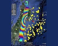
Paris, France (ESA) Mar 31, 2011 Satellite images have been essential for helping relief efforts in Japan following the massive quake that struck on 11 March. Now scientists are using ESA's space radars to improve our understanding of tectonic events. Scientists are calling on data from the advanced radar on ESA's Envisat satellite to map surface deformations caused by the magnitude-9 earthquake. Studying data acquired o ... read more |
|
| The content herein, unless otherwise known to be public domain, are Copyright 1995-2010 - SpaceDaily. AFP and UPI Wire Stories are copyright Agence France-Presse and United Press International. ESA Portal Reports are copyright European Space Agency. All NASA sourced material is public domain. Additional copyrights may apply in whole or part to other bona fide parties. Advertising does not imply endorsement,agreement or approval of any opinions, statements or information provided by SpaceDaily on any Web page published or hosted by SpaceDaily. Privacy Statement |

 del.icio.us
 Digg
Digg Reddit
 YahooMyWeb
 Google