 |
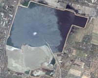
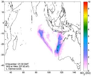
Paris, France (ESA) Nov 16, 2010 Since its latest series of deadly eruptions, Java's Mt Merapi has been spewing volcanic ash clouds into the air. Satellite data are crucial for assessing the eruption's danger to air traffic and public safety. Mt Merapi began erupting on 26 October and has killed more than 200 people. Numerous international flights in and out of the Indonesia area have been cancelled due to ash clouds. Flying through such clouds is a threat to safety because the damaging particles can lead to engine failure. For instance, on 28 October a Thomas Cook Scandinavia Airbus flew through the Merapi cloud en route from Indonesia to Saudi Arabia, with a stop in Batam. Once in Batam, it was discovered that the engines were damaged and had to be replaced. Volcanic Ash Advisory Centres (VAACs) are responsible for gathering ash cloud information and assessing the risks to aviation. Australia's Darwin VAAC is using satellite data of the plume to issue its forecasts. Dr Andrew Tupper of the Bureau of Meteorology said: "The updates from ESA have been very useful to Darwin VAAC when received in real time, and we expect that in the post-event analysis we'll be able to show lots more potential value." Satellites help VAACs by providing information on ash and the trace gases, such as sulphur dioxide, erupting into the atmosphere. ESA sends sulphur dioxide email alerts in near-real time. A map around the location of the sulphur dioxide peak is put on a dedicated web page, provided in the email. This Support to Aviation Control Service is based on data from ESA's Envisat, Eumetsat's MetOp and NASA's Aura satellites. The animations to the right show the sulphur dioxide plume and its movement from Indonesia towards Australia during 4-13 November. To know whether aircraft may pass safely under or over ash clouds and to forecast cloud movement, the VAACs need more accurate information on the altitude and vertical size of ash plumes. ESA started the 'Support to Aviation for Volcanic Ash Avoidance' project as a demonstration that uses satellite data and wind measurements to compute the injection heights of volcanic emissions. Flight disruptions from Mt Merapi's ash cloud echo the situation faced in Europe in April and May when Iceland's Eyjafjallajoekull volcano spewed huge amounts of ash and grounded numerous flights. In May, ESA and Eumetsat co-hosted a meeting with some of the world's leading scientists to look at improving how Earth observation satellites can support the VAACs. ESA and Eumetsat are now working to implement a set of recommendations that were outlined at the event. Operational satellites like Europe's Meteosat Third Generation and the planned Global Monitoring for Environment and Security (GMES) Sentinels will ensure volcanic ash monitoring from space well into the future.
Share This Article With Planet Earth
Related Links Envisat Earth Observation News - Suppiliers, Technology and Application
 Enhancing Sustainable Development Of Earth
Denver CO (SPX) Nov 12, 2010 From monitoring vanishing glaciers to the accounting of forestry, hydropower and mining assets as steps to boost sustainable development here on Earth, the power of satellite remote sensing plays an increasingly vital role. These topics and others are highlighted in the Fall 2010 issue of the quarterly print and online publication - Imaging Notes magazine. "Secure World Foundation in ... read more |
|
| The content herein, unless otherwise known to be public domain, are Copyright 1995-2010 - SpaceDaily. AFP and UPI Wire Stories are copyright Agence France-Presse and United Press International. ESA Portal Reports are copyright European Space Agency. All NASA sourced material is public domain. Additional copyrights may apply in whole or part to other bona fide parties. Advertising does not imply endorsement,agreement or approval of any opinions, statements or information provided by SpaceDaily on any Web page published or hosted by SpaceDaily. Privacy Statement |

 del.icio.us
 Digg
Digg Reddit
 YahooMyWeb
 Google