 |
Boulder CO (SPX) Mar 25, 2011 The Secretary of the Interior Ken Salazar has announced plans to make the Department of the Interior the permanent manager of the Landsat series of Earth observation satellites. "Bringing the Landsat satellite mission under USGS is not only the best scientific and fiscal plan for the country," said Secretary Salazar, "but also will bring stability to the high tech employers that hire and build these systems right here in the United States. Landsat drives innovation and job-creation at many levels of our economy, from the satellite manufacturers that build the technologies to the water managers, farmers, and resource managers across the West and around the world who rely on its data for smart and efficient operations." Secretary Salazar announced the plans after touring Ball Aerospace, the maker of a key instrument on the Landsat Data Continuity Mission (LDCM) which is the next, and final, satellite in the Landsat series, if future plans are not adopted. NASA Chief Scientist Waleed Abdalati, Assistant Secretary for Water and Science Anne Castle, U.S. Geological Survey Director Marcia McNutt, and CEO and President of Ball Aerospace David Taylor joined Secretary Salazar at today's event. Under the plans announced by Secretary Salazar and included in the President's 2012 budget submission, the Department of the Interior's United States Geological Survey (USGS) will become the permanent budgetary and managerial home for future Landsat satellites missions, a recommendation that was also endorsed by the past Administration. Landsat satellites capture data about the Earth's surface that no other private or public source can provide. This unique data has become vital to agricultural, water management, disaster response, scientific, and national security uses, providing hundreds of millions of dollars in estimated value to the U.S. economy per year. The USGS already owns and operates the two Landsat satellites currently in orbit and is working in partnership with NASA to develop the LDCM satellite mission. NASA's expertise will be retained under the announced plans, with NASA continuing to build and launch future Landsat satellites for USGS. The plans will require Congressional approval to be finalized. "Images from Landsat satellites flying over 400 miles above the earth tell us a whole range of stories about the land," said USGS Director Marcia McNutt. "A permanent Landsat home will ensure that we continue to see the land so broadly, so distinctly, so objectively, that we can better understand our lands and manage them more efficiently, based on science, for the benefit of the American people." "We were very pleased to have an opportunity to show Secretary Salazar the progress being made on the Operational Land Imager instrument, the key technology development for the next Landsat Earth Imaging Satellite," said Ball Aerospace president and CEO, David L. Taylor. "The Ball-built sensor will provide the vital capability to continue LandSat Earth observations into a fourth decade." "NASA has worked with USGS to support the Landsat series of satellites from their inception and believes a permanent USGS-based program will ensure a path of continued innovation in the 21st century," said Dr. Waleed Abdalati, Chief Scientist at NASA. "As an R and D agency, NASA will continue to support the Landsat program by developing and testing the technologies needed to meet the nation's future remote sensing needs. The Landsat Data Continuity Mission will hopefully mark the beginning of a new phase for the Landsat series under USGS's leadership, with the continued benefit and support of NASA's expertise." Once operating from approximately 440 miles overhead, Ball Aerospace's Operational Land Imager (OLI) instrument will digitally image the Earth's land surface in 185 km (115 mi.) swaths. These orbital characteristics allow global land features to be observed every 16 days at a medium-scale resolution, in which each picture element, or pixel, portrays an area about the size of a baseball infield. This resolution is optimal for observing both natural and human-induced land conditions worldwide. From a technical perspective, the OLI provides 30-meter multispectral and 15-meter panchromatic land-image data. Following the tour, Secretary Salazar joined students from Skyline High School, a state of the art Science, Technology, Engineering and Mathematics (STEM) school, for a discussion on the importance of science and innovation in the classroom. "As our future scientists, it is important that these students understand the Department's role in space-based science and how they can make a positive impact on the Colorado economy by pursuing high tech jobs," said Secretary Salazar. "I applaud schools like Skyline for providing the resources and training needed to create an innovative workforce."
Share This Article With Planet Earth
Related Links US Department of the Interior Earth Observation News - Suppiliers, Technology and Application
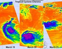 NASA IR Satellite Imagery Shows Cyclone Cherono Dwindling
Greenbelt MD (SPX) Mar 23, 2011 Three days of NASA infrared satellite imagery provides a clear picture to forecasters of the effect wind shear has had on former Cyclone Cherono. Wind shear increased near Cyclone Cherono this weekend and weakened it down to a remnant low pressure area in the Southern Indian Ocean. Cherono's remnants have moved away from Mauritius and still causing ocean swells. NASA's Aqua satellite flew ... read more |
|
| The content herein, unless otherwise known to be public domain, are Copyright 1995-2010 - SpaceDaily. AFP and UPI Wire Stories are copyright Agence France-Presse and United Press International. ESA Portal Reports are copyright European Space Agency. All NASA sourced material is public domain. Additional copyrights may apply in whole or part to other bona fide parties. Advertising does not imply endorsement,agreement or approval of any opinions, statements or information provided by SpaceDaily on any Web page published or hosted by SpaceDaily. Privacy Statement |

 del.icio.us
 Digg
Digg Reddit
 YahooMyWeb
 Google