 |
Bonn, Germany (SPX) Dec 22, 2010 On 14 December 2010, TanDEM-X passed another important milestone: the radar mission's test phase has concluded in less than six months according to plan, paving the way for routine operations - the collection of elevation data - in 2011. The TanDEM-X mission was developed by the German Aerospace Center in collaboration with Astrium, and is operated from DLR Oberpfaffenhofen. The objective of the mission is to create a highly accurate three-dimensional elevation model of Earth's entire surface. Immediately after it was launched to its 514-kilometre high orbit on 21 June 2010, the satellite was operating nominally, and sent back its first high resolution images after just three and a half days. TanDEM-X was thoroughly tested and calibrated over the following months. This included the first close formation flight with TerraSAR-X, launched in 2007, during which the two radar satellites flew at a distance of just a few hundred metres from each other. This formation flight made it possible to take simultaneous images of Earth's surface from two different points of view - crucial to the three-dimensional mapping of the entire globe. "The next step towards our global three-dimensional map was commissioning the control and processing chains and confirming the predicted quality of the first digital three-dimensional models," says Dr. Manfred Zink, TanDEM-X Project Manager for the ground segment at DLR. Completion of this phase means that now nothing stands in the way of full operation in early 2011.
A global network of ground stations Along with the stations for TerraSAR-X, this adds up to a global network of more than 10 ground stations. This makes possible the 'handover', in which a ground station has to switch from one satellite to the other in less than 20 seconds as they fly overhead. After optimised data transmission, precise knowledge of how close to each other the two satellites are flying is essential. This baseline must be known to within a millimetre. Deviations from this precision can lead to altitude errors of up to a metre in the final map. The satellites are equipped with special GPS receivers, built by the German Research Center for Geosciences, Potsdam (Geo-Forschungszentrum GFZ), which enable high-precision location determination. Combined with geographical reference data, this makes possible the necessary millimetre-accuracy baseline information. This procedure can also be verified.
Our world in three dimensions One example of the commercial exploitation of this accurate data is via the creation of topographical maps. The first data provided by the satellites has already been used for crisis management in response to the eruption of the Indonesian volcano Mount Merapi, by predicting the movement of lava flow. Due to this it was possible to evacuate affected areas in time.
Share This Article With Planet Earth
Related Links TanDEM-X Earth Observation News - Suppiliers, Technology and Application
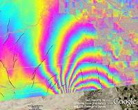 Mexico Quake Studies Uncover Surprises For California
Pasadena CA (SPX) Dec 21, 2010 New technologies developed by NASA and other agencies are revealing surprising insights into a major earthquake that rocked parts of the American Southwest and Mexico in April, including increased potential for more large earthquakes in Southern California. At the fall meeting of the American Geophysical Union in San Francisco, scientists from NASA and other agencies presented the latest r ... read more |
|
| The content herein, unless otherwise known to be public domain, are Copyright 1995-2010 - SpaceDaily. AFP and UPI Wire Stories are copyright Agence France-Presse and United Press International. ESA Portal Reports are copyright European Space Agency. All NASA sourced material is public domain. Additional copyrights may apply in whole or part to other bona fide parties. Advertising does not imply endorsement,agreement or approval of any opinions, statements or information provided by SpaceDaily on any Web page published or hosted by SpaceDaily. Privacy Statement |


 del.icio.us
 Digg
Digg Reddit
 YahooMyWeb
 Google