 |
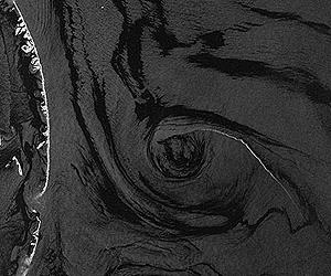
Bonn, Germany (SPX) Aug 04, 2010 If an oil spill wasn't responsible for the formations in these TerraSAR-X images, they might seem like the work of an artist. The images were acquired over the Gulf of Mexico on 9 July 2010. For researchers, such imagery is key in forecasting the distribution of the oil slick. TerraSAR-X mapped the oil-polluted area in the Gulf of Mexico in a series of images acquired on 9 July 2010. The environmental catastrophe started on 20 April 2010 when an explosion sank the Deepwater Horizon drilling rig and the shut-off valves on the wellhead could not be closed. The Artificial Barrier Island, an artificial island constructed by heaping dredged sand, situated to the east of the Chandeleur Islands, is easily recognisable in the TerraSAR-X imagery and it will soon be awash with spilled oil. "The imagery indicates that man-made constructions cannot offer much protection," reports Susanne Lehner, team leader of radar oceanography at the DLR Remote Sensing Technology Institute (Institut fur Methodik der Fernerkundung; IMF). "The current plays a role, the wind drives the oil further and the waves dissipate the oil slick - all this makes containment of the oil difficult." Scientists are able to calculate the effect of these factors with the aid of TerraSAR-X data. "For example, when we know the wind speed, we are in a position to ascertain how and where the oil will drift."
Oil, ships and drilling rigs viewed by radar The frayed offshoots reaching out from the individual oil slicks reveal that the oil was driven forward by the wind. Ships and drilling rigs are visible clearly as points on the water's surface. "In the process of evaluating the radar data, one must always take account of windless regions or naturally occurring areas of algae that also appear black, since the radar beams are reflected away from the receiver," explains Susanne Lehner.
Forecast for the drift of the oil "Fish oil decomposes within a day and is often used by fishermen as bait," explains oceanographer Susanne Lehner. While research vessels are on site collecting data on currents and wind, TerraSAR-X is simultaneously charting the corresponding region from an altitude of over 500 kilometres, using its radar. The team is evaluating approximately 30 high-resolution images and further experiments will follow. "The TerraSAR-X images are ideal for this forecasting, since their resolution allows one to chart and follow rapidly-varying processes close to the coast in real time extremely well," says the oceanographer. Evaluation of the data also allows the team to draw inferences on the age and type of the oil slick. The experiment is part of the 'DeMarine' project, which is supported by DLR. Monitoring and forecasting the drift of slicks is one of five sub-projects. In contrast, Bill Emery from the University of Colorado is using the image captured by TerraSAR-X as a reference survey. The scientist flew over the region in the Gulf of Mexico in a Twin Otter turboprop and tested various onboard instruments. His route commenced in Pascagoula and led him out to the site of the Deepwater Horizon rig. "We saw an increasing volume of oil and tar on the surface of the water, and there were many vessels operating in the areas between the slicks and deposits," reports the scientist. "It was an impressive and simultaneously depressing sight."
Share This Article With Planet Earth
Related Links German Aerospace Center (DLR) Earth Observation News - Suppiliers, Technology and Application
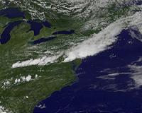 GOES-13 Satellite Sees Severe Storms Strike US East Coast
Greenbelt MD (SPX) Jul 29, 2010 One of the most destructive storms in years struck Washington, D.C. and the surrounding area on July 25, 2010. Strong winds downed trees and power lines, leaving hundreds of thousands of residents without power, stopping elevators, and darkening malls and movie theaters. Falling trees killed at least two people. The following morning, crews were working furiously to restore power to homes, ... read more |
|
| The content herein, unless otherwise known to be public domain, are Copyright 1995-2010 - SpaceDaily. AFP and UPI Wire Stories are copyright Agence France-Presse and United Press International. ESA Portal Reports are copyright European Space Agency. All NASA sourced material is public domain. Additional copyrights may apply in whole or part to other bona fide parties. Advertising does not imply endorsement,agreement or approval of any opinions, statements or information provided by SpaceDaily on any Web page published or hosted by SpaceDaily. Privacy Statement |

 del.icio.us
 Digg
Digg Reddit
 YahooMyWeb
 Google